

Africa Moves to Implement ‘Correct the Map’ Resolution as Equal Earth Cartographers Pledge Support
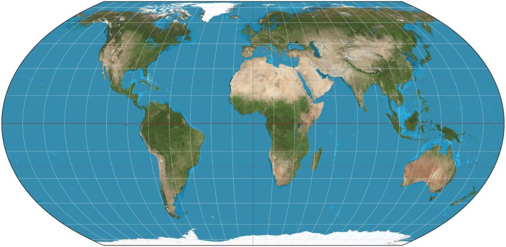
Togo and the African Union are working with Equal Earth designers to put the UN’s “Correct the Map” resolution into practice through education, mapping and technical support.
The three cartographers behind the Equal Earth map projection have agreed to provide scientific and technical support to Togo and the African Union as Africa begins implementing the United Nations General Assembly’s “Correct the Map” resolution.
Tom Patterson, Bernhard Jenny and Bojan Šavrič made the commitment during a virtual meeting on September 20 with Togo’s Foreign Affairs Minister, Professor Robert Dussey, who led the African Union-backed resolution at the UN.
The resolution, A/RES/80/307, was adopted by the UN General Assembly on September 4 with 164 votes. It encourages governments, schools, international organisations, media organisations and technology companies to use equal-area map projections where the relative size of territories is important.
At the centre of the implementation effort will be the Equal Earth projection, developed by Patterson, Jenny and Šavrič and published in the International Journal of Geographical Information Science in 2018.
Unlike the widely used Mercator projection, which enlarges areas increasingly towards the poles, Equal Earth was designed to preserve the relative areas of continents while retaining recognisable continental shapes.
The distinction has particular significance for Africa, whose landmass can appear substantially smaller on some commonly used world maps than its actual area relative to Europe and other northern-hemisphere regions.
The Equal Earth projection has already gained institutional traction. NASA’s Goddard Institute for Space Studies adopted it after its publication, while the projection has also been integrated into Esri software. The African Union subsequently selected it as its institutional cartographic reference through decision Assembly/AU/Dec.959 (XXXIX).
Under the implementation discussions, the three designers are expected to support countries and institutions adopting equal-area projections, contribute to the development of freely usable reference maps and assist with educational resources for African schools.
The initiative moves the debate beyond how maps are drawn towards how geographical information is produced, taught and consumed.
For African education systems, the proposed resources could give students access to maps that represent the continent’s land area more proportionately, while governments and institutions could use standardised reference material when communicating spatial and geographical information.
Togo is also preparing a concept note for a proposed scientific advisory group to support implementation of the UN resolution. The three Equal Earth designers have been invited to participate in their personal capacities.
Dussey described the initiative as part of a broader effort to address what he called “cognitive justice” in the way Africa is represented geographically.
“A fair map does not change geography: it changes the way we look at the world,” he said, arguing that the process begins with how children learn to situate their continent.
Related Posts
 Airbus A350F Freighter Takes Flight as Cargo Market Shifts Toward Newer, More Efficient Aircraft
 Uganda Architects to Celebrate 60 Years as Profession Confronts a Technology-driven Future
 Oyo Nyimba: The King Who Made Tooro Feel Close to the World
 In Karamoja, an 80-day Sorghum Variety Offers a Different Response to Drought
 UNBS Seizes 17,770 Litres of Illicit Alcohol as Kenya Deaths Raise Regional Concern
 Relief as UAE Eases Ebola-era Entry Curbs on Ugandans, Reopening Key Aviation Corridor
Get business news delivered to you everyday
Latest News

Airbus A350F Freighter Takes Flight as Cargo Market Shifts Toward Newer, More Efficient Aircraft

Uganda Architects to Celebrate 60 Years as Profession Confronts a Technology-driven Future

Africa Moves to Implement ‘Correct the Map’ Resolution as Equal Earth Cartographers Pledge Support

Oyo Nyimba: The King Who Made Tooro Feel Close to the World

In Karamoja, an 80-day Sorghum Variety Offers a Different Response to Drought

UNBS Seizes 17,770 Litres of Illicit Alcohol as Kenya Deaths Raise Regional Concern

Why Unlocking Africa’s Next Mining Powerhouse Requires Strong Financial Partnerships

Equity Turns Schools into Climate Restoration Hubs as Lender Launches 200,000-tree Uganda drive

13 Feared Killed as Tracep Aviation L-410 Crashes in DRC

IATA Warns Cargo Screening Alone Cannot Contain Undeclared Dangerous Goods Risk